

Land Surveyors in Orlando, Florida
Polysurveying has been surveying land for more than 50 years, and our Orlando field office serves projects across the Orlando area. From boundary surveys to site plans, we deliver precise, dependable results for your project.
Whether you’re planning a new build or need precise land measurements, we’ll guide you from the first call through the finished drawing.
Free quotes. Orlando field office: (407) 495-1260.
Land Surveying Services in Orlando, FL
Comprehensive surveying services tailored to your project in the Orlando area.
- Boundary Survey
- Precisely defines property lines to resolve disputes and support construction planning.
- Plot Plan / Site Plan
- Detailed layouts of existing and proposed structures for planning and permit applications.
- Stakeout Survey / Construction Layout
- Guides contractors with precise positioning of foundational and structural elements.
- Foundation Survey / Form Check
- Checks formwork accuracy before concrete is poured, to meet compliance standards.
- ALTA Survey
- A comprehensive survey built to ALTA/NSPS standards for real estate transactions.
- Topographic Survey
- Detailed mapping of elevation, contours, and features of the land.
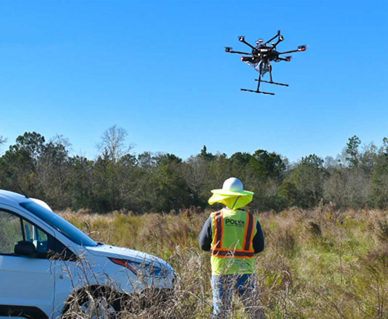
GPS, Drones, and Robotic Instruments
We use state-of-the-art equipment, including GPS, drones, and robotic instruments, for precise results.
In the field, our team uses advanced technology like GPS and drones to accurately map and mark your property.
About Polysurveying
Polysurveying has been a trusted land surveying partner for more than 50 years. Our commitment to precision and customer satisfaction shapes how we work on every project.
As part of planning every survey, we review local regulations, so your survey fits the requirements for your project and the Orlando area.
Our Surveying Process
-
Consultation and quote
Reach out by phone or through our online form to discuss your project and get a personalized quote.
-
Research and planning
We gather the documents and data we need, including deeds and plats, and review local regulations to prepare for the survey.
-
Field survey
Our team uses advanced technology like GPS and drones to accurately map and mark your property.
Why Choose Polysurveying?
Experience
More than 50 years of land surveying experience across Alabama, Florida, Mississippi, and Georgia.
An Orlando field office
Our Orlando field office puts experienced surveyors within reach of your site.
Current technology
GPS, drones, and robotic instruments help us deliver precise results.
A clear process
Three simple steps, from your first call to the finished survey, so you know what to expect.
Flexible scheduling
We offer flexible scheduling and expedited services for urgent projects.
Personalized quotes
Tell us about your project and we’ll give you a personalized quote with no hidden costs.
Where We Work
Polysurveying handles land surveying jobs and projects in Alabama, Florida, Mississippi, and Georgia, and we provide free quotes to anyone who needs land surveying services.
- Orlando, Florida and surrounding areas
- Orlando field office: (407) 495-1260
- Also serving Jacksonville, Florida
- Also serving Tallahassee, Florida
- Corporate office in Mobile, Alabama
Common Questions About Land Surveying
What is the purpose of a land survey?
A land survey identifies your property boundaries and any potential issues, such as encroachments or easements, so you can build, buy, or sell with confidence.
Do I need a survey for a property purchase?
Yes. A survey is crucial for identifying property boundaries and potential issues like encroachments or easements.
How much does a survey cost?
The cost varies based on property size, location, and survey type. Contact us for a tailored estimate.
How long does the survey process take?
Surveys typically take from a few days to two weeks, depending on complexity and regulatory requirements.
Can surveys be expedited?
Yes. We offer flexible scheduling and expedited services for urgent projects.
What types of surveys do you offer?
We offer boundary, topographic, ALTA, and other specialized surveys to meet diverse needs. See the full list on our land surveying services page.
What technology do you use for surveys?
We use state-of-the-art equipment, including GPS, drones, and robotic instruments, for precise results.
Get a Free Land Surveying Quote in Orlando
Take the first step toward a successful project. Whether you’re planning a new build or need precise land measurements, we’re here to help. Contact us today or request a quote to get started.
Disclaimer: All survey work performed by field divisions is in responsible charge at direction of the Corporate office. All research, assignment, coordination, drafting, billing and review are completed out of the Corporate office.